On Sunday we drove from Westport to Franz Josef which took up the majority of the day. Our journey took us past some of the famous black beaches of Okarito, a colony of Cape Fur Seals and 'The Pancakes' rock formations.
The drive was absolutely stunning as the road wound it's way along the coast line with the cliffs and roaring sea to one side and luscious, green rainforest to the other.
The next stop was The Pancakes rock formation just off the coast, named because they look like stacks of pancakes jutting out from the sea. We had a lovely walk around, despite the slightly dreary weather, discovering the many different rock formations created by weathering and erosion.
We walked back through a section of the rainforest that covers much of this area. The road that we were following is one of the only highways and there are only a small number of settlements off it, such as Franz Josef, population 330. The continuous stretch of wilderness has been recognised as a World Heritage Site.
We spent the evening in Franz Josef joining at 80s party at the bar which resulted in a very late bedtime for Louise and myself. Error.
On Monday we took part in an Ice Explorer trip on the glacier. We got a helicopter part way up the glacier and then had a three hour trek on the ice with our group and expert guide. Despite a fairly terrible hangover I had an amazing time and the icy air helped clear my head.
Our first glimpse of the impressive glacial formation. Franz Josef is a unique glacier as it is one of only three in the world to extend below 300m above sea level and it is situated amidst a temperate rainforest rather than a colder environment. Only it's neighbouring Fox Glacier and one in Patagonia descend into rainforests.
The glacier is 7 and a half miles long although it is in a period of rapid retreat and therefore is getting noticeably shorter each year. It is believed that this is due to global warming and worryingly it is predicted that by 2100 the glacier could retreat by 5km losing upto 38% of its mass.
In steeper parts of the glacier steps were carved into the ice making it easier for us to clamber upwards. The glacial landscape changes each day due to the glaciers unusually fast flow. Therefore, formations that we saw on our trip would not necessarily be there for other explorers.
The glacier was named by the German explorer Julius Von Haast in 1865 after the Austrian Emperor Franz Joseph I. However, in Maori it is known as Ka Roimarta o Hinehhkatere (The Tears of Hinehukatere) and there are many variations of the legend that gave the glacier it's name. The one we were told by our guide went something like this:
"Hinehukatere was a young snow maiden who lived in the mountains and fell in love with a mortal villager, Wawe. She was forbidden by the Gods to bring him into the mountains but insisted on doing so anyway to share her love of climbing with him. Unfortunately, an avalanche swept Wawe from the mountain side to his death leaving Hinehukatere devastated. Her many tears formed a river cascading down the mountain until eventually, the Gods feeling bad for denying her love, froze the tears to form the glacier in tribute."
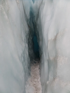
Above is one of the smallest ice tunnels that I just about managed to squeeze through. It was difficult getting into due to my height as the entrance was extremely low as well as being rather narrow. I had to go sideways along it, no easy feat with giant boots and crampons on as you have to shuffle due to the restriction on either side not allowing you to put one leg in front of the other. If that wasn't difficult enough there was a tight, almost 90 degree turn which we had to struggle round. I've never experienced claustrophobia in my life but that came pretty close. I was excessively glad to get out the other side, (photo below).
Yet another small space that we squeezed through, having to turn sideways to fit. The gorgeous blue colour is caused by light waves refracting when they hit the ice mass, so I've been informed. My science knowledge isn't the best.
The 'death hole' named because if you fall down it there is a very slim chance of getting back out. It is thought that this hole goes right down to the bed rock underneath the glacier. Below is a photo of the river flowing from the glacier to the sea, around 20km away. The ice explorer walk was fantastic and a brilliant way to start the day. The different formations were beautiful and my inner geography geek was dying of happiness, seeing as we studied the glacier during sixth form.
After our, more strenuous than usual, morning activity we visited the hot pools with some of the other kiwi travellers. We spent an idyllic two hours switching between the different temperature pools, 36C, 38C and 40C, and chatting to one another before eventually deciding it was time to leave, if we didn't want to become prunes. A wonderful pizza buffet followed and an evening of packing and watching Sherlock Holmes awaited. Yet another blissful day.
Until next time.
A x


No comments:
Post a Comment